Saturday, February 20, 2010

Free GIS Sofware for Mapping Climate Change

Maps are a way to visualize changes in the earth and its climate in times to come. At ClimateShift, we have some GIS shapefile maps available. More shapefiles, free software plus free GIS tutorials are available at MapCruzin.com. There are many free GIS applications and more coming all the time, but none so far seem to be as complete and full featured as MapWindow. You can use MapWindow:

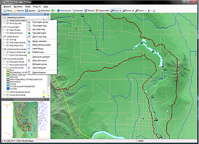
  • As your main desktop GIS
  • As an alternative desktop GIS
  • To distribute data to others
  • To develop and distribute custom spatial data analyses


MapWinGIS ActiveX Control

At the core of the MapWindow application is the MapWinGIS ActiveX control. Using this control, you can program custom mapping functionality directly into your own software.

  • Open source component (free distribution)
  • Complete GIS API for shapefile and grid data
  • Many built in GIS functions

What makes this GIS tool different than the others?

MapWindow is Open Source so you develop your own plug-ins if desired. MapWindow is free to use and redistribute to your clients and other end users.


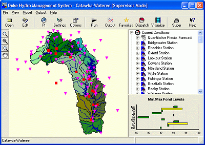
Unlike other free tools, MapWindow is more than just a data viewer, it is an extensible geographic information system. This means that you can write plug-ins to add additional functionality (models, special viewers, hot-link handlers, data editors, etc.) and pass these along to any number of your clients and end users.

MapWindow includes standard GIS data visualization features as well as DBF attribute table editing, shapefile editing, and grid importing and conversion.

MapWinGIS ActiveX includes a GIS API for shapefile and grid data with many built in GIS functions.


MapWinGIS ActiveX can be redistributed royalty-free. No fee is required, although we happily accept donations to help support this effort.

Download MapWindow Free GIS.


If you are new to GIS, Check out the free Learn2Map GIS Tutorial and Shapefile Atlas.

Renewable and Alternative Green Energy Maps and Shapefiles - Wind, Solar, Biomass...

Here is our collection of energy related maps and ArcGIS GIS shapefile map layers including both conventional non-renewable and green renewable and alternative sources of energy. Check back often as we update this page frequently.

U.S. Green Renewable Wind Energy Maps by State.

Free Energy Maps

United States Coalbed Methane Maps.

Oil and Gas Related Maps

Residential Energy Consumption Maps by U.S. Census Divisions.

World Energy Maps by county.

Renewable Energy Atlas of the West: A Guide to the Region's Resource Potential.

U.S. Regional Oil and Gas Field Maps.

Renewable Energy Potential Maps by U.S. Census Divisions.

Go to: Free Maps, Free Shapefiles, Creating Maps

Free Energy GIS Shapefiles

Renewable and Alternative Green Energy ArcGIS Shapefiles by U.S. State

* U.S. Renewable Energy Biomass Shapefile.

* U.S. Wind Energy Shapefiles.

* U.S. Renewable Energy Hydrogen Shapefile.

* U.S. Renewable Energy Electric Transmission Shapefile.

* U.S. Renewable Energy Solar Shapefiles.

* Oil and Gas Field ArcGIS Shapefile Maps.

International Renewable Energy Wind Potential Shapefiles by country.

Dowload renewable energy maps and GIS shapefiles


Sunday, February 7, 2010

Helen Caldicott: How Did President Obama Become Champion of Nuclear Power?

In 1983, Barack Obama, a senior at Columbia University described his visions of a "nuclear free world" in an article titled "Breaking the War Mentality" in the university newsmagazine, Sundial. He described discussions of "first- versus second-strike capabilities'' that "suit the military-industrial interests'' with their "billion-dollar erector sets,'' and called for the abolition of the global arsenals of tens of thousands of deadly warheads. As a candidate he acknowledged that he was worried for the safety of his children who lived in Illinois because it has the highest concentration of nuclear reactors in the US - and opposed further nuclear subsidies. "I am not a nuclear proponent," he said...

Read Helen Caldicott: How Did President Obama Become Champion of Nuclear Power? and view videos


Carbon Sequestration Atlas of the United States and Canada

The Department of Energy’s (DOE’s) National Energy Technology Laboratory (NETL) is proud to release the first Carbon Sequestration Atlas of the United States and Canada. Production of this Atlas is the result of cooperation and coordination among carbon sequestration experts from local, state, and government agencies, as well as industry and academia. This Atlas presents the first coordinated assessment of carbon capture and storage (CCS) potential across the majority of the U.S. and portions of western Canada. The Atlas also provides an introduction to the carbon storage (sequestration) process, summarizes the DOE’s Carbon Sequestration Program, and gives information about the CCS contributions from each Regional Carbon Sequestration Partnership (RCSP) to date.

Read entire article and download Carbon Sequestration Atlas of the United States and Canada


add this